
Shenandoah Epic 2024 GPS FAQ
- Dec 17, 2023
- 4 min read
Updated: Dec 18, 2023
The Shenandoah Epic is paving the way for GPS use in an Adventure Race, so naturally, there are some questions regarding its use and how the whole process works with the addition of a GPS device. We have put together a comprehensive Frequently Asked Questions section below that should answer all your questions. If there are items that are still unclear, feel free to reach out to us at info@adventureenablers.com, and we can add to the list and get all your questions answered.
What type of GPS devices are allowed?
You are allowed to use any type of GPS device; there are no restrictions.
Are there different divisions for using a GPS?
There are no separate divisions for GPS users. The course is specifically designed with GPS use in mind. This does not mean that you cannot complete the race without a GPS; it will just be easier if you have one. If we mix GPS and non-GPS racers on the same course at the same time, it is difficult to monitor usage and prevent data sharing and people following each other across divisions.
What other standard AR rules are changing?
None. All other rules, apart from the usual rule that says GPS devices are not allowed, remain the same for this event.
Can I use my GPS device to communicate with others?
No. You are only allowed to use the mandatory cell phone or your GPS device to communicate with emergency services or the race director. All other communication with any type of device is prohibited.
Isn’t it expensive to buy a GPS device?
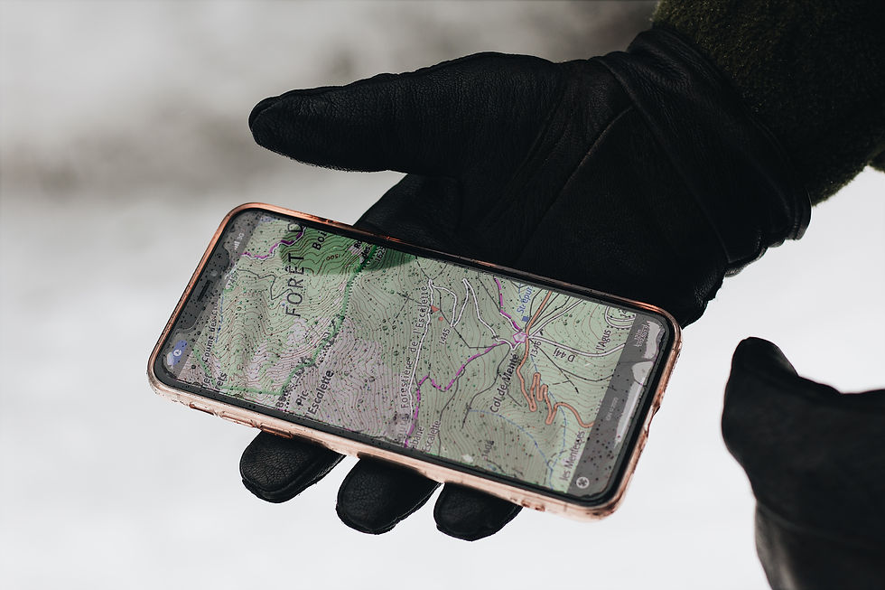
If you have a modern cell phone, you already have one of the best devices for aiding GPS navigation in the backcountry. There are many apps you can download to use during the event to help you get around the course. Finding the best app and learning how to use it is part of the learning curve and one of the challenges of this event. Nearly everyone should already have some type of device they can use and should not need to buy anything special for GPS navigation. That said, there is a host of purpose-made devices, including watches and standalone GPS units, that can be used for air navigation.
What GPS device would you recommend?
Use the one you already have, which is likely your cell phone. Whatever device you plan to use, get familiar with uploading a GPX file to the device, and make sure you know how to use it for navigation in the backcountry. If you plan on using a GPS device, don't show up on race day without ever having used it, expecting it to be a simple matter of getting it set up and ready to head out into the woods.
I want to use my phone, but I am not sure about cell service. How will that work?
Make sure you use a map or app that can use offline maps. Download maps for the Bentonville, VA area within a 25-mile radius. You can also navigate with a GPS device without any background maps.
How will I get the course into my GPS device?
On race morning, we will provide each team with a USB drive containing a GPX file with all the checkpoints. We will also post the files on the event webpage. We will have Wi-Fi available at the start area so you can connect to the internet and download the files. You will need to know how to get the files uploaded to your GPS device. It's not mandatory but having the files on your device will make navigating to the points much easier.
Do you have a sample file I can practice uploading to my GPS device?
Yes, here is a link to a sample file that you can practice with. It is the same method of download and file format as you will get on race day. There are six points in the file. Click here to download the file. Upload the file to your device and make sure they line up with the following locations.
Buzzard Rock 38.94175, -78.30168
Downriver Canoe Company 38.83835, -78.32991
Hazard Mill Farms 38.85068, -78.34719
Little Crease Shelter 38.86969, -78.35980
Signal Knob 38.96028, -78.33102
Woodstock Tower 38.87041, -78.44941
Because you are allowing GPS devices, is it still an Adventure Race?
Absolutely. An adventure race is not defined by map and compass skills alone; it encompasses much more. Among other things it is about teamwork, training, nutrition, camaraderie, biking skills, trekking skills, paddling skills, endurance, problem-solving, route finding, planning, decision-making, stepping out of your comfort zone, enjoying the outdoors, battling the weather, navigation, equipment selection, the unknown adventure, and completion.
Will we still get maps?
Yes, one map will be provided per team. They are essential as they will display no-travel areas and additional information not found in the GPX files.
Do I still need map and compass skills?
Having map and compass skills will be helpful. While some GPS devices can be used for navigating entirely in the backcountry, they may not show all the features displayed on the maps we provide. Carrying a compass is mandatory, and it's a good idea to know the basics in case something happens to your GPS device.
Any specific equipment tips?
Just like any piece of equipment, make sure you know how to use it before race day. Ensure you have a way to protect your device and keep the battery charged. Understand how to get GPX files onto your device.
You say the course is designed with the use of GPS in mind; what does that mean?
As with all adventure races, the course is kept secret until the race. Rest assured, the course will be challenging and incredibly fun.
Because of the inclusion of GPS devices, how does that affect any of the inclusions in the Adventure Race Series?
The Epic will earn points toward the USARA series. It will not be a regional qualifier. Click here to read the well-put-together thoughts on GPS devices by USARA. We will be covering the cost of one team to go to USARA nationals through a lottery system. Points will be awarded toward the AR World Series North American series.


Comments